New technology helps us to better know our forests
With the help of modern data, we can further improve the planning of the work to be done in the forest so that we do the right things in the right place at the right time . This saves both money and the environment, as cost-effectiveness and sustainability go hand in hand in the forest and we can say that “less is more.”
The future looks bright for Finnish forests
Our forests are in good condition. They are growing well and cutting potential has increased steadily .
“Finland lives off the forest. A substantial part of the Finnish GDP and exports come from the forest industry. The forest sector is also a major employer. I believe that we understand the importance of forests in Finland and we always look after their sustainability. Felling continues to be less than growth, and when forests are harvested, they are regenerated. This is a fundamental for us, and Finland will always uphold it,” says Niina Riissanen, Senior Officer, at the Ministry of Agriculture and Forestry .
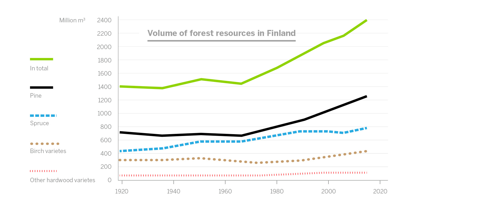
Natural Resources Institute Finland has monitored the condition of the Finnish forests through the National Forest Inventory of Finland (NFI) since the 1920s and thanks to these accurate measurements, Finland is a forerunner in inventorying forest resources. We know our forest assets better than any other country.
The data from the NFI help us to monitor the sustainability of forest use. Thanks to the data, we know exactly how much wood we have and of what kinds.
The data from the NFI helps us to monitor the sustainability of forest use. “We have precise data on the quantity of stands, felling and the need for forest management work. For example, we know that there are many untended young forests and unused harvesting opportunities in Finland at the moment,” says Riissanen.
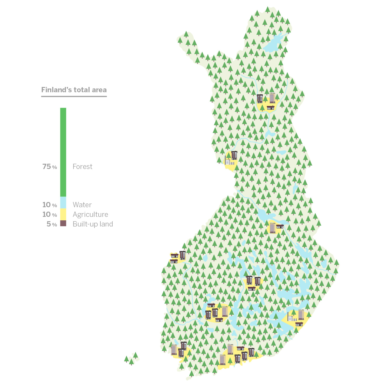
Finland’s forests flourishing
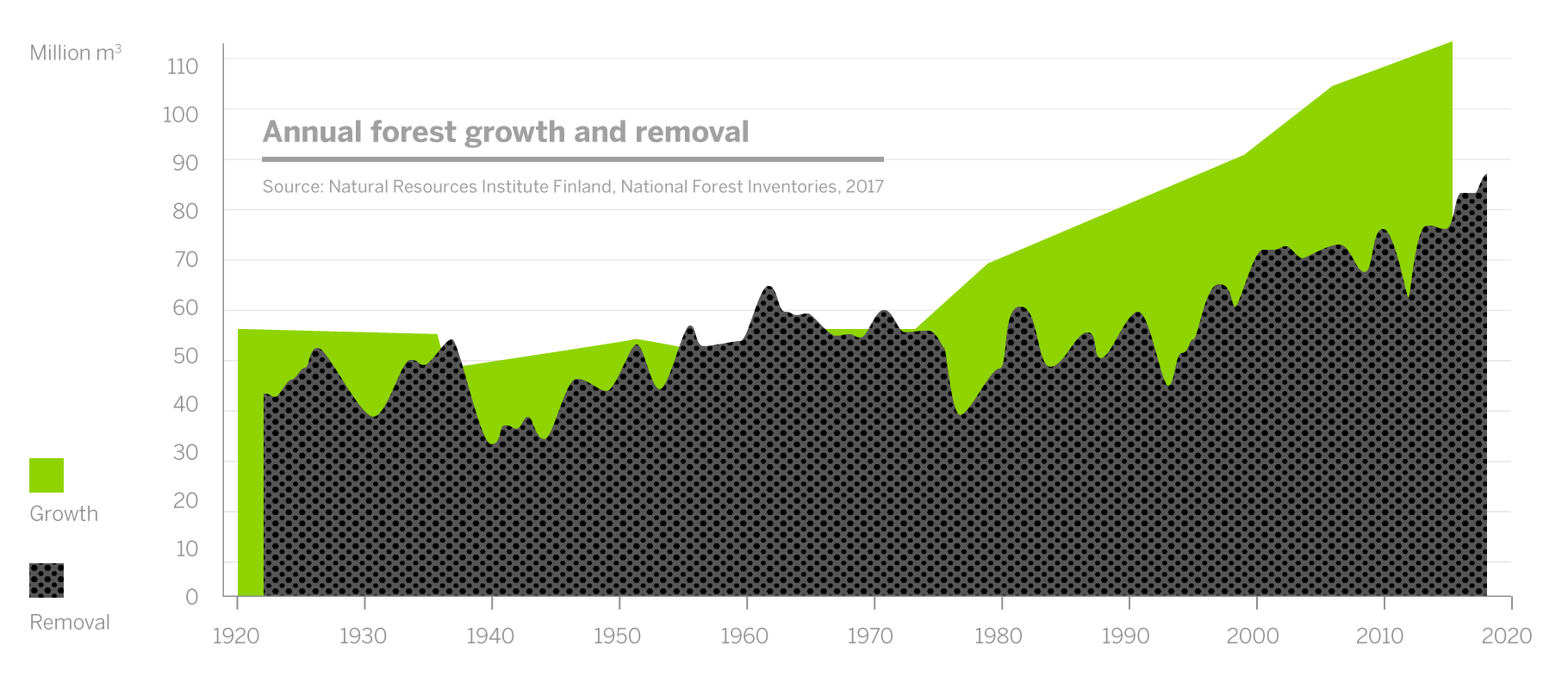
According to Natural Resources Institute Finland’s latest measurements, there is now more wood in our forests than ever before. Over the past 50 years, the annual growth of forests has doubled, and the volume of growing stock now is 2.4 billion cubic metres. The forests are growing roughly at a rate of 110 million cubic metres a year, and sustainable felling opportunities amount to approximately 80 million cubic metres. The annual growth of forests now exceeds the amount felled and natural loss by over 20 million cubic metres.
“The good state of Finnish forests can be explained by long-term and systematic forest management and sustainable use, a favourable age structure, and the reduction of partially wooded forests . Climate change, i.e. the rise of the average temperature globally, has also speeded up forest growth,” says Niina Riissanen from the Ministry of Agriculture and Forestry.
Safeguarding the availability of forest assets and biodiversity are an essential part of the sustainable management and use of forests. “Sustainable forestry has economic, ecological, social and cultural sustainability dimensions,” Riissanen goes on to say.
Economic sustainability means preserving the vitality and productivity of forests. Ecological sustainability is safeguarded by maintaining the biodiversity of the forests. Social sustainability includes securing the benefit from forests for citizens and different operators . Cultural sustainability is upheld by taking the culturally significant sites in our forests into consideration.
“New data collection methods and the more efficient utilisation of data help us to take all four pillars of sustainability into account,” says Riissanen.
Forest certification communicates sustainable use of forests
A forest certificate is a sign that wood raw material has been procured from sustainably and legally managed forests. A total of 85 per cent of Finnish commercial forests are certified.
Certification serves to ensure biodiversity and the preservation of habitats and biotopes typical of forests. Certification also safeguards the rights of people working in forests and ensures that forests can continue to be used for recreational purposes.
“When wood used by Metsä Group arrives at the mill gates, we can say with 100 per cent certainty where the wood is from. The wood we use is always traceable and from certified or controlled forests,” says Janne Soimasuo, Environmental Manager at Metsä Group.
Responsible decisions with modern data
The technology used in collecting forest asset data is being developed continuously. It is now possible to obtain more comprehensive information regarding forests through laser imaging, and aerial and satellite photographs, for example. Also, terrain examinations have also moved into the digital era – digital cameras and ground laser scanners produce precise data on the shape of tree trunks, the number of branches and the health of stands.
“The inventorying of Finland’s forests is of a truly high standard. The starting point is fantastic, as decisions and investments regarding forest use can be made on the basis of reliable factual information,” says Soimasuo.
“When we have the information we need on the terrain and stands from remote sensing and other sources, we can plan in advance how best to carry out forest management and which industrial raw material should be produced from which tree trunk. The aim is to identify the upgrade value of different felling sites as early as possible and to make products of the highest upgrade value possible from the wood,” says Soimasuo.
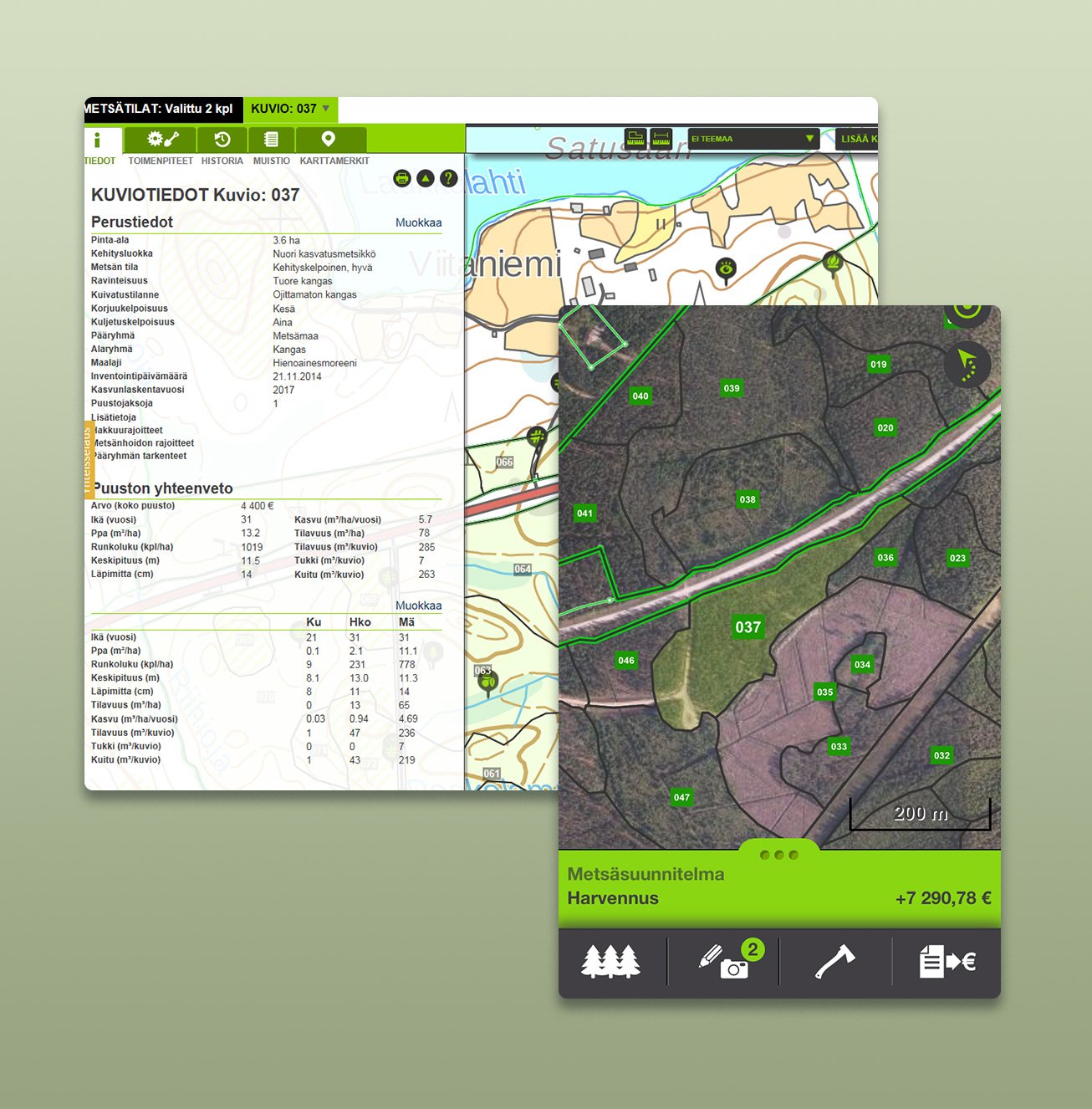
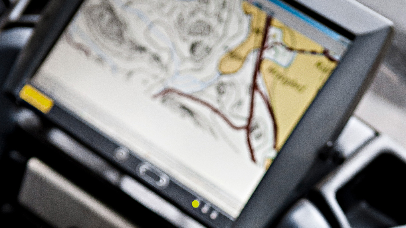
Forest work planners have at their disposal data on stands as well as maps and aerial photographs from several different sources.
Forest work planners have at their disposal data on forests as well as maps and aerial photographs from several different sources. Combining these materials gives you a clear overall picture of a stand’s ground conditions, the quality of the growth stock and any endangered species.
Unique forest asset data
The forest data produced for Finnish forest owners is unique in the world. The data gathered by the Finnish Forest Centre is compiled in the metsaan.fi service. Forest owners can use the service to find out what their forests are like: what kinds of trees, habitat and nature value there are, and how the forest can be used – or not.
“Combining data on nature with forest asset data supports the sustainability of our forests, as the earlier we know what there is in a forest, the better it can be taken into account in planning,” says Riissanen from the Ministry of Agriculture and Forestry.
In the future, forest asset data will be openly available to everyone online if the legislation on forest data changes. “I see a great potential in opening up the forest asset data. It would bring new jobs and services to the sector,” continues Riissanen.
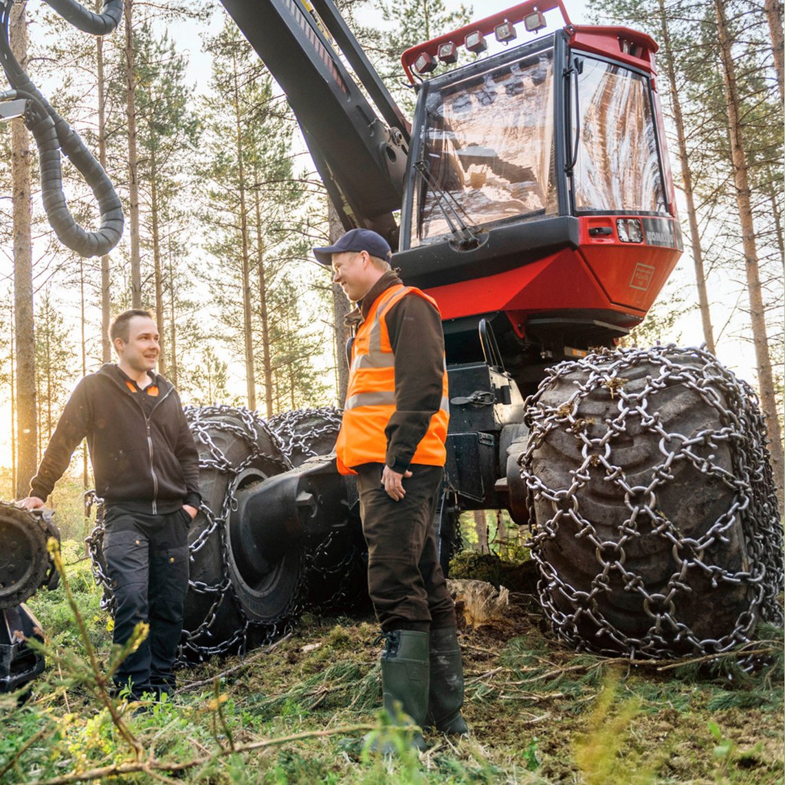
Responsible harvesting
The more precise the stand data is, the better the forest work can be planned. The work is faster and better quality when the features of the terrain and important locations of natural value are taken into consideration in forest work.
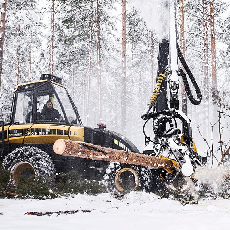
Generally, the cut-to-length method is used in harvesting. This means that the tree is felled, cut to size and sorted in the forest, and is then driven along logging tracks to be stacked by wood type at the roadside. “From the harvesting instructions and stock map of the harvester, the operator ensures that important issues relating to the environment, occupational safety and efficiency, such as the slope and load-bearing capacity of the terrain as well as valuable natural sites, are taken into consideration,” says Janne Soimasuo.
The stock map contains all the information that needs to be taken in to account during harvesting.
The data gathered by the harvester is utilised in planning forest transport. On the basis of this information, the driver of the forwarder knows the location of the woodpiles and quagmires , and how to best utilise logging tracks in order to get all the trees out of the forest and to the roadside in a cost-effective and nature-saving way. “Sturdy routes and eradicating unnecessary journeys save money and nature,” says Soimasuo.
Careful planning of logging tracks saves money and nature
Careful planning of logging tracks, that is to say the routes to be used in the forest, is a crucial part of responsible harvesting. The shape of the stand as well as the load-bearing capacity and slope of the terrain are taken into account in the logging tracks. The aim is to have a network of logging tracks where trees can be felled and transported from the forest on the land with the best load-bearing capacity available without damaging terrain or trees.
Logging tracks are planned so that trees can be felled and transported from the forest to roadside storage areas along the land with the best load-bearing capacity available without damaging terrain or trees.
In the future, harvesters will further ease the work of their operators and give guidance in the planning of logging tracks. “There are harvesters being tested that have sensors which measure the depth of logging tracks. This means that the tracks left by harvesters can be continuously monitored and quality reports given to the forest owner,” says Metsä Group’s Janne Soimasuo.
A harvestability map lets you know when to go to a forest site
Trafficability maps let you know when forests are mature enough for harvesting, i.e. when to go to a forest site . They make the year-round harvesting of wood possible, as they help to identify sites where the land has not frozen and those where winter harvesting can take place.
Harvesting validity maps let you know when a forest site can be visited. Summer and winter harvesting sites are clearly marked on the maps.
The maps make work more efficient and reduce damage to terrain and trees. Furthermore, they provide harvesting professionals with the conditions for good year-round operations.
“There is great potential in harvesting validity maps – for both productivity and responsibility. Winter and summer sites are clearly distinguished on the maps, and they show you locations where the terrain’s carrying capacity is low so you can avoid them. At the same time, those sites that can be harvested when the ground is thawed can be identified. This reduces seasonal variations in harvesting and improves the utilisation rate of harvesters,” says Riissanen from the Ministry of Agriculture and Forestry.
Well-planned soil preparation pays for itself quickly
Metsä Group has long been a forerunner in the development of high-quality soil preparation techniques. In soil preparation, the surface layer of forest land is broken so the seedlings to be planted or the seeds to be sown get the best possible growth ground in terms of humidity and heat conditions.
Soil preparation is done with a mechanical excavator or harrow. A suitable method of soil preparation is selected based on the lushness, soil type and moisture conditions at the growing site. “A correctly chosen soil preparation method that is well executed will quickly pay for itself, because in the right kind of soil, the seedlings will quickly spurt into growth and the new forest gets a good start,” says Metsä Group’s Janne Soimasuo.
“Metsä Group has been developing a mound inverting method for soil preparation that provides seedlings with good growth conditions and reduces the amount of brushwood. The machine turns small mounds over to make beds for new seedlings. The surface of the soil is only broken slightly on each mound, which reduces nutrient runoff,” continues Soimasuo.
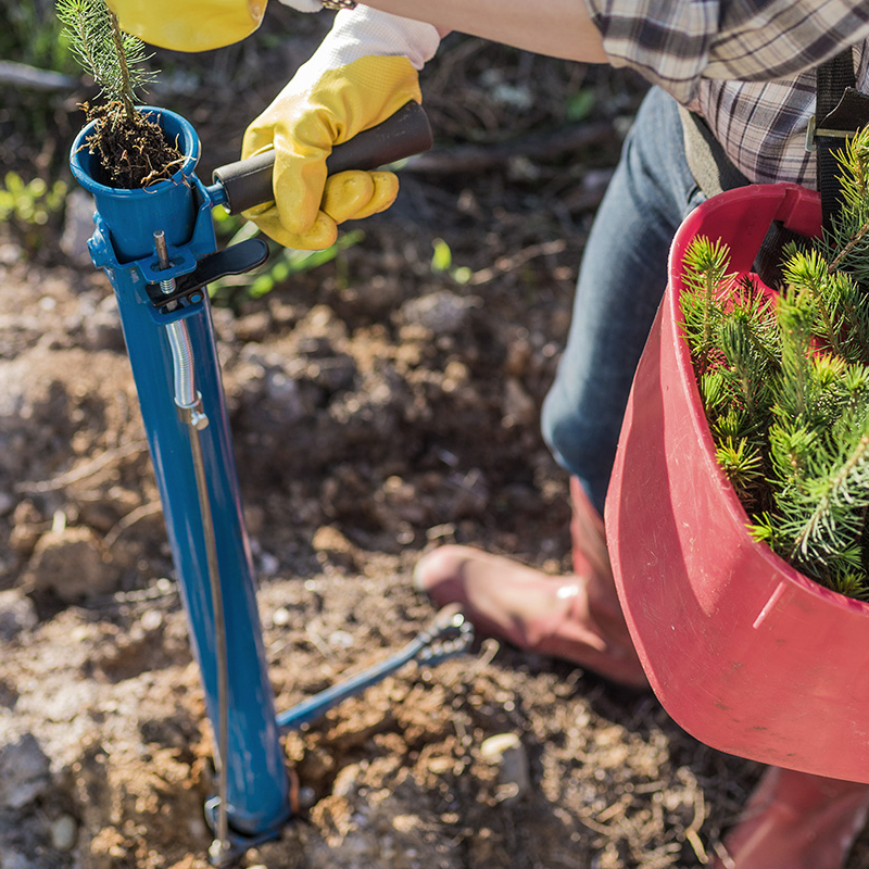
Precision in seedling planting and seed sowing
After soil preparation, the forest is ready for new seedlings or seeds. The most suitable species of tree and types of seedling are selected according to the fertility of the terrain and the goals of the forest owner. “With the help of stand data, the most suitable regeneration method and species of tree can be selected for the growing area. Well-planned and quickly executed regeneration will result in a healthy seedling stand and reduce the risk of forest damage and the need for early treatment,” says Soimasuo .
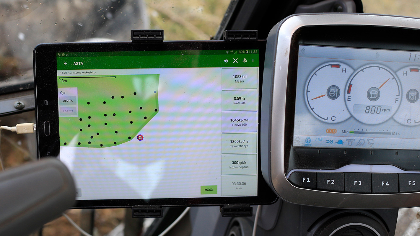
Metsä Group and Risutec Oy have together developed the Asta application, which is installed on excavators and monitors the surface area and density of planting spots in real time. Thanks to the application, each mound and its location data are recorded in the data system. It makes the operator’s job easier and the monitoring of the number of planting spots and the quality of preparation work more accurate.
Using a GPS sensor attached to the boom of the excavator, the Asta application measures the surface area and location of planting spots of the area under preparation. A map of the plot being worked on is plotted on the operator’s tablet PC or smartphone.
Thanks to the application, a precise report of what kind of surface area has undergone soil preparation and how many planting spots have been prepared on the plot can be submitted to forest owners who have ordered soil preparation from Metsä Group. Asta then makes it possible to order just the right number of seedlings for the actual number of planting spots, making planting work significantly more efficient. The same application can be used in planting machines, where it gives the number of seedlings planted.
The newest features of Asta include the measurement of rehabilitated ditches, the selection of mound type and the possibility to mark valuable natural habitats on the map. All this brings cost-effectiveness and responsibility to soil preparation work.
Read and learn more about our intelligent forests.
Virtual forests are here, and digitalisation is paving the way for intelligent wood products. Read more about how professionals in the field see the future of the forest industry.
Janne Soimasuo Janne Soimasuo has an M.Sc. in forestry and is Environmental Manager at a Finnish forest industry company Metsä Group. Soimasuo has worked for Metsä Group for over 20 years, mainly in positions relating to sustainable forest management and planning. In his present position, he is responsible for environmental matters relating to domestic wood procurement and forest certification.
Niina Riissanen Niina Riissanen (M.Sc. in forestry) is Senior Officer at the Ministry of Agriculture and Forestry. Riissanen has worked for the ministry for ten years, and she has gained long and varied experience of the Finnish forest industry. At the moment, Rissanen’s area of responsibility covers projects related to Finland’s National Forest Strategy. Forests are a part of Riissanen’s life, including in her free time. She participates in forest management, and she also picks mushrooms and berries and goes orienteering.
 Metsä Forest
 Metsä Wood
 Metsä Fibre
 Metsä Board
 Metsä Tissue